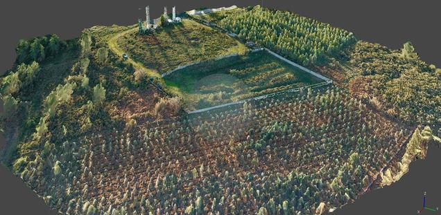
Cartography and topography services with drones

GRIDFLIGHT transforms topography with the use of drones, generating detailed and accurate maps that facilitate the interpretation of the terrain. Our technology allows us to obtain terrain data quickly and efficiently, making the process of planning and executing projects easier than ever.

dron
null

Much more than a camera

Drones stand out among traditional topographic methods because of their ease of access to complicated terrain, since with them it is not necessary to enter personally to carry out the measurement.

Topographic drones

A topographic drone is dedicated to capturing terrain data from above to perform tasks of recognition, photogrammetry, cartography, topographic surveys, LIDAR...

Benefits of generating topographic maps with drones

GRIDFLIGHT generates quality results in a fast way

Capturing topographic data with a drone is definitely faster than with other terrestrial methods. In addition, surveying topographic data requires less labor, so costs will also be saved.

GRIDFLIGHT generates quality results in a cost-effective way

Drones dedicated to topography make it possible to capture relief and terrain composition data with 3D technology in a precise and exhaustive way, being able to represent the map in different vector formats. The use of RTK technology makes the results robust and accurate.

GRIDFLIGHT generates quality results in a safe way

One of the most notable features of drones dedicated to obtaining topographic data is the ease of access to places that, due to their orographic characteristics, would hardly be accessible by traditional measurement tools.

You're in good hands

Paintec is a drone operating company under the State Aviation Safety Agency.

We have all the necessary certifications to fly drones that will meet your needs.

Logotipos de aesa y del ministerio de fomento

Frequently Asked Questions: Topographic Services with Drones

What are drones used for in topography?

Topographic drones generate detailed terrain models, including complex or difficult to access areas, which later allow us to work on the data obtained quickly and accurately.

How is a topographic survey carried out with drones?

The versatility of topographic drones allows them to capture images of the ground from multiple points of view that will later be processed to create orthomosaics and 3D models.

What kind of results can you expect with drone surveying?

Topographic drones can produce data in the following formats: orthomosaic maps, digital surface models, digital terrain models, level curves, point clouds, broken lines, orthophotos, etc.

How accurate is a topographic survey with drones?

At GRIDFLIGHT we use high-resolution topographic drones, achieving an accuracy of up to 0.18 cm in optimal terrain conditions.